

Open Notify是一个开源项目,旨在为NASA的一些出色数据提供简单的编程接口。
open-notify.org 的作者做了一些工作,以获取原始数据并将其转换为与太空和航天器有关的API。
本文将通过这个接口,获取得到国际空间站的位置,并实时地绘制到地图上:
感谢cr0sis/Real-time-International-space-station-tracker
为了实现本文的目标,你得先安装ISS_Info:
pip install ISS-Info
下面分步骤讲解整套绘制流程
1.地图初始化
为了实时展示国际空间站的路径,需要使用turtle绘制曲线,因此可以创建一个turtle画布,将背景设为地球:
import ISS_Info
import turtle
import time
import json
import urllib.request

screen = turtle.Screen()
screen.setup(720,360)
screen.setworldcoordinates(-180,-90,180,90)
screen.bgpic("map.png")
screen.bgcolor("black")
screen.register_shape("isss.gif")
screen.title("Real time ISS tracker")

iss = turtle.Turtle()
iss.shape("isss.gif")
2.获取空间站的人数
如果能知道空间站上的宇航员人数,我们就能更加准确的跟踪国际空间站。幸运的是open-notify确实提供了这样的接口。
为了获取人数信息,我们必须向:
http://api.open-notify.org/astros.json
请求拿到数据,并将相应的宇航员名字写在左上角:
astronauts = turtle.Turtle()
astronauts.penup()
astronauts.color('black')
astronauts.goto(-178,86)
astronauts.hideturtle()
url = "http://api.open-notify.org/astros.json"
response = urllib.request.urlopen(url)
result = json.loads(response.read())
print("There are currently " + str(result["number"]) + " astronauts in space:")
print("")
astronauts.write("People in space: " + str(result["number"]), font=style)
astronauts.sety(astronauts.ycor() - 5)

people = result["people"]

for p in people:
    print(p["name"] + " on: " + p["craft"])
    astronauts.write(p["name"] + " on: " + p["craft"], font=style)
    astronauts.sety(astronauts.ycor() - 5)
3.绘制空间站位置
为了能够绘制空间站的实时位置,我们需要请求拿到空间站的位置信息。请求的接口是:
http://api.open-notify.org/iss-now.json
不过作者将其封装成了一个函数,我们直接调用 iss_current_loc 即可,循环获取国际空间站位置:
while True:
    location = ISS_Info.iss_current_loc()
    lat = location['iss_position']['latitude']
    lon = location['iss_position']['longitude']
    print("Position: \n latitude: {}, longitude: {}".format(lat,lon))
    pos = iss.pos()
    posx = iss.xcor()
    if iss.xcor() >= (179.1):           ### Stop drawing at the right edge of
        iss.penup()                     ### the screen to avoid a
        iss.goto(float(lon),float(lat)) ### horizontal wrap round line
        time.sleep(5)
    else:
      iss.goto(float(lon),float(lat))
      iss.pendown()
      time.sleep(5)
我们还可以标出自己目前所处的位置,以查看和国际空间站的距离及空间站经过你上空的时间点(UTC)。
# 深圳
lat = 112.5118928
lon = 23.8534489

prediction = turtle.Turtle()
prediction.penup()
prediction.color('yellow')
prediction.goto(lat, lon)
prediction.dot(5)
prediction.hideturtle()

url = 'http://api.open-notify.org/iss-pass.json?lat=' +str(lat-90) + '&lon=' + str(lon)
response = urllib.request.urlopen(url)
result = json.loads(response.read())

over = result ['response'][1]['risetime']

prediction.write(time.ctime(over), font=style)
不过这里值得注意的是,iss-pass.json这个接口的纬度计算必须在-90到90之内,因此深圳的纬度需要减去90.
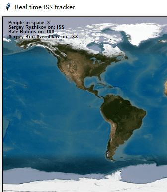
最终效果如下:

在Python实用宝典公众号后台回复“国际空间站”或者“ISS”即可获得本文完整源代码哦。
我们的文章到此就结束啦,如果你喜欢今天的 Python 教程,请持续关注Python实用宝典。
有任何问题,可以在公众号后台回复:加群,回答相应验证信息,进入互助群询问。
原创不易,希望你能在下面点个赞和在看支持我继续创作,谢谢!
Python实用宝典 ( pythondict.com )
不只是一个宝典
欢迎关注公众号:Python实用宝典

评论(0)